OCRACOKE, N.C. – Coast Guard crews and good Samaritans rescued three fishermen after their fishing vessel began taking on water and sank Monday in the Pamlico Sound northeast of the Brant Island Shoal.
Crew from the Good Samaritan fishing vessel, Miss Kelly, relayed a mayday call to Sector North Carolina watchstanders at 6:10 a.m., Monday that the 58-foot commercial shrimper, Cracker Boy, was taking on water, and the water level was already above the engines. One fisherman from the Cracker Boy was transferred to the Miss Kelly while the other two remained aboard.
Two 25-foot Response Boat – Small crews from Station Ocracoke and Station Hobucken, Station Hobucken 41-foot Utility Boat crew, and Station Hatteras Inlet 47-foot Motor Life Boat crew launched to assist.
The Station Ocracoke RB – S crew arrived on scene at 7:16 a.m. and used dewatering pumps to try and keep up with the flooding. Another good Samaritan, 50-foot fishing vessel, Morning Star, arrived at the same time and attempted to tow the Cracker Boy but was unable.
Petty Officer 3rd Class Matt Harris from Station Hatteras Inlet was aboard the sinking vessel when a wave came over the boat.
The roll was slow, and Harris never felt like he was in any danger, said Chief Petty Officer Arnold Head, executive office in charge of Station Hatteras Inlet.
The vessel quickly sank after taking the wave and rolling.
The remaining two fishermen and Harris were rescued by the Station Hobucken RB – S crew and Station Hatteras Inlet RB – S crew then transferred the fisherman to the Morning Star. The crewmember from the Miss Kelly also transferred to the Morning Star whose crew took them to Pamlico Point.
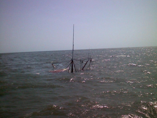
The vessel Cracker Boy sank in position 35 degrees 09.74 minutes north latitude and 076 degrees 14.84 minutes west longitude in approximately 20 feet of water. The Station Ocracoke RB – S crew has marked the sunken vessel with a buoy.
OCRACOKE, N.C. – Coast Guard crews and good Samaritans rescued three fishermen after their fishing vessel began taking on water and sank Monday in the Pamlico Sound northeast of the Brant Island Shoal.
Crew from the Good Samaritan fishing vessel, Miss Kelly, relayed a mayday call to Sector North Carolina watchstanders at 6:10 a.m., Monday that the 58-foot commercial shrimper, Cracker Boy, was taking on water, and the water level was already above the engines. One fisherman from the Cracker Boy was transferred to the Miss Kelly while the other two remained aboard.
Two 25-foot Response Boat – Small crews from Station Ocracoke and Station Hobucken, Station Hobucken 41-foot Utility Boat crew, and Station Hatteras Inlet 47-foot Motor Life Boat crew launched to assist.
The Station Ocracoke RB – S crew arrived on scene at 7:16 a.m. and used dewatering pumps to try and keep up with the flooding. Another good Samaritan, 50-foot fishing vessel, Morning Star, arrived at the same time and attempted to tow the Cracker Boy but was unable.
Petty Officer 3rd Class Matt Harris from Station Hatteras Inlet was aboard the sinking vessel when a wave came over the boat.
The roll was slow, and Harris never felt like he was in any danger, said Chief Petty Officer Arnold Head, executive office in charge of Station Hatteras Inlet.
The vessel quickly sank after taking the wave and rolling.
The remaining two fishermen and Harris were rescued by the Station Hobucken RB – S crew and Station Hatteras Inlet RB – S crew then transferred the fisherman to the Morning Star. The crewmember from the Miss Kelly also transferred to the Morning Star whose crew took them to Pamlico Point.
The vessel Cracker Boy sank in position 35 degrees 09.74 minutes north latitude and 076 degrees 14.84 minutes west longitude in approximately 20 feet of water. The Station Ocracoke RB – S crew has marked the sunken vessel with a buoy.