PORTSMOUTH, Va. — The Coast Guard is scheduled to discontinue 166 navigational aids within the Virginia Inside Passage (VIP) due to shoaling and other navigational safety concerns throughout the area.
Fixed aids to navigation will be removed as Coast Guard resources permit over the next several years and will be listed under an Advance Notice in future Local Notice to Mariners.
The decision follows a 2013 proposal, which identified 241 navigational aids for removal. The Army Corps of Engineers completed water surveys in 2015, and the Coast Guard, working with the state of Virginia, completed an environmental assessment in March. Following the public comment period, the Coast Guard evaluated 42 public comments and took feedback from local, state and congressional members.
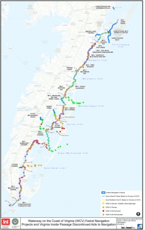
The Coast Guard will continue to maintain navigational aids in Wachapreague Inlet, Great Machipango Inlet, Chincoteague Inlet and certain sections in the vicinity of Quinby Creek/Inlet that are scheduled to be dredged periodically by the Army Corps of Engineers to maintain a safe, navigable waterway. Additionally, it was determined natural deep water exists near Folley Creek, Wallops Island and at the southern tip of the VIP just northeast of the Chesapeake Bay Bridge where portions are planned to be remarked with floating buoys because the fixed aids no longer mark good water. The Coast Guard will keep or replace 52 aids and will reevaluate 23 aids upon conclusion of dredging projects.
The Coast Guard is responsible for providing navigational systems, information and services that enable safe navigation. Many of the aids within the VIP no longer accurately mark the waterway and may be misleading to the mariner – a condition potentially more dangerous than having no aids to navigation at all.
The Coast Guard continues to work with federal, state and local partner agencies regarding the viability of marking the waterways; however, the respective waterways must be reasonably stable and of sufficient depth for the Coast Guard to safely service the area.
"Removing 166 navigational aids is not a decision we take lightly," said Capt. Jerry Barnes, the 5th Coast Guard District chief of prevention. "With our decision, we are balancing the needs of the local communities with the availability of federal funds to maintain these waterways. Our navigational aids guide mariners, and the presence of navigational aids signifies the Coast Guard deems a waterway safe. With the extent of shoaling in these areas, we are unable to provide a safe navigation system and cannot in good conscience continue to mark them."
PORTSMOUTH, Va. — The Coast Guard is scheduled to discontinue 166 navigational aids within the Virginia Inside Passage (VIP) due to shoaling and other navigational safety concerns throughout the area.
Fixed aids to navigation will be removed as Coast Guard resources permit over the next several years and will be listed under an Advance Notice in future Local Notice to Mariners.
The decision follows a 2013 proposal, which identified 241 navigational aids for removal. The Army Corps of Engineers completed water surveys in 2015, and the Coast Guard, working with the state of Virginia, completed an environmental assessment in March. Following the public comment period, the Coast Guard evaluated 42 public comments and took feedback from local, state and congressional members.
The Coast Guard will continue to maintain navigational aids in Wachapreague Inlet, Great Machipango Inlet, Chincoteague Inlet and certain sections in the vicinity of Quinby Creek/Inlet that are scheduled to be dredged periodically by the Army Corps of Engineers to maintain a safe, navigable waterway. Additionally, it was determined natural deep water exists near Folley Creek, Wallops Island and at the southern tip of the VIP just northeast of the Chesapeake Bay Bridge where portions are planned to be remarked with floating buoys because the fixed aids no longer mark good water. The Coast Guard will keep or replace 52 aids and will reevaluate 23 aids upon conclusion of dredging projects.
The Coast Guard is responsible for providing navigational systems, information and services that enable safe navigation. Many of the aids within the VIP no longer accurately mark the waterway and may be misleading to the mariner – a condition potentially more dangerous than having no aids to navigation at all.
The Coast Guard continues to work with federal, state and local partner agencies regarding the viability of marking the waterways; however, the respective waterways must be reasonably stable and of sufficient depth for the Coast Guard to safely service the area.
"Removing 166 navigational aids is not a decision we take lightly," said Capt. Jerry Barnes, the 5th Coast Guard District chief of prevention. "With our decision, we are balancing the needs of the local communities with the availability of federal funds to maintain these waterways. Our navigational aids guide mariners, and the presence of navigational aids signifies the Coast Guard deems a waterway safe. With the extent of shoaling in these areas, we are unable to provide a safe navigation system and cannot in good conscience continue to mark them."