

SWC Forums
Pull up a chair...let's talk fishing.

Check out wavecast. It could definitely change but right now it looks like a close call or hit for the SE US. And check out the gulf. Something blowing up very near to SE Texas. Frame 57.

GFS model out 8 days. Not good.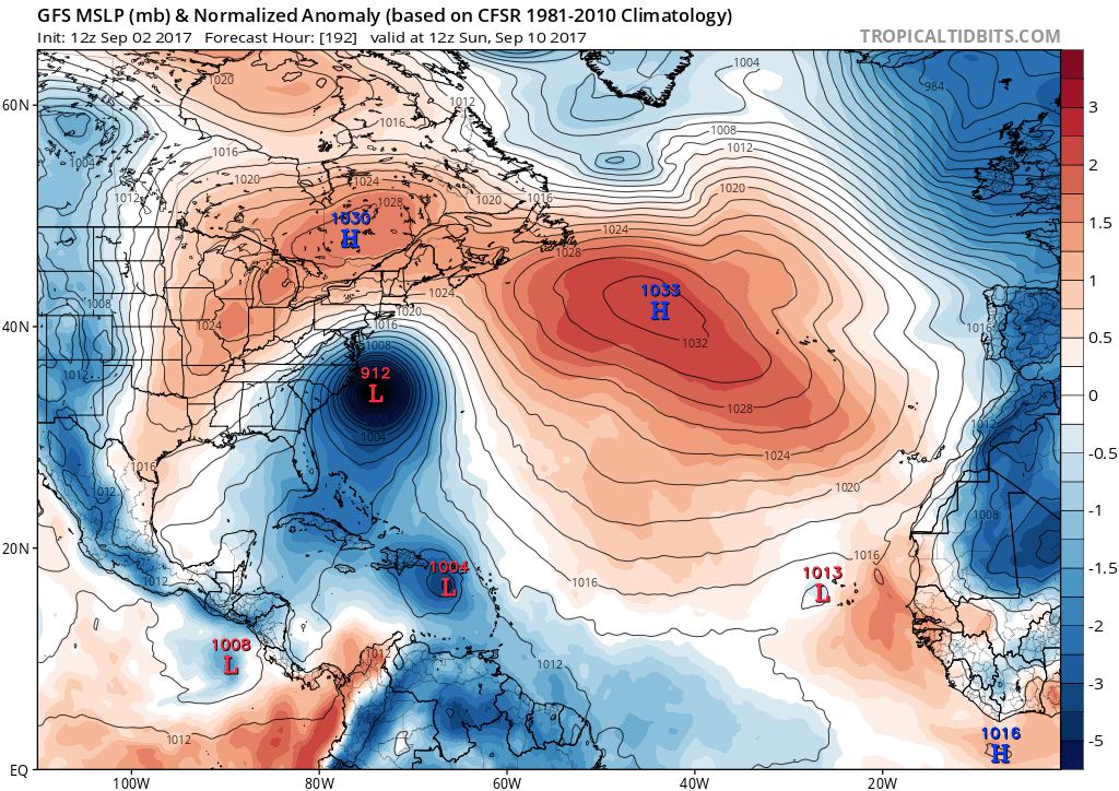

tropicaltidbits.com has a good GFS guestimater site for Irma. Real early in program but now show a direct hit on SE NC with a millabar guess at 887=26.04 inchs on Monday Sept 11. Hugo near Charlotte was at 27.24 inchs. Euro model shows a more OTS curve to the right than NOAA also. Mid week upper winds aloft should give a good clue
These models are better than they used to be. If you watch these storms closely, nowadays, the NHC more or less gets the track right on their advisories. The intensity forecasts are still a crapshoot, but in general, the tracks arent that off. Science is a good thing.
The major models are more or less in agreement now, which is strange in that they almost never do this far out, and they put it coming right up the Cape Fear River. Just by the angle of approach of this thing, a few degrees one way or another can mean hundreds of miles of variance in the actual landfall, but the 5 AM advisory does not look good for the islands or the East Coast. An African wave that develops south of 20N lat, with a blocking high in place over the Atlantic, is generally a recipe for a US hit.
All joking and politics aside, God bless everyone. Hope I'm wrong, but I wouldn't wait until Friday to figure out a gameplan to cut and run....

I just watched WaveCast.....that is not good. It is also showing in reefcast. Boys....start planning.
Jason is on it. GFS out just now was consistent with the previous run and the European model last night. This would be a devastating landfall for Oak Island, Wilmington, Carolina and Wrightsville Beach. Still a ways out and any small shift would have a big impact of the path, but it is time to make plans.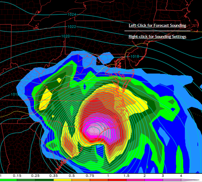
Dang right devastating . These storms push water like a freighter in front right side. Hazel had a 17ft wall of water at OKI . Stoves/beds/springs etc washed just across Davis canal at 3rd street. Long about Wed or Thur will be praying for a nice upper level jet stream. ADDS a old aviation site has good projected winds aloft forecast java. Hugo winds aloft at FL 300 from CHS to SDF were at that time 150 degrees at 50 kts all the to Louisville. Watched this wind on a 737 FMS not knowing how bad it would get.
18z model runs have shifted west. Almost a certainty now we will have a landfall or a very close shave somewhere in the SE US late next weekend into early next week. The center of the "spaghetti" isn't dead on the Cape Fear for now, but we are now firmly on the right-hand side, which isn't ideal either. In my opinion, it's splitting hairs at this point.
I'm kinda thinking the broadcast news is going to jump onboard with this tonight or tomorrow morning, so now would be a great time to buy some plywood, a generator, bread, and water. And several cases of beer....
The last run of the Euro model has it turning due north and missing us, but it is 8-9 days out. Way too early to know much for sure.
The last run of the Euro model has it turning due north and missing us, but it is 8-9 days out. Way too early to know much for sure.
Let's hope.... it will be a close call at the least.
Looking much better for NC/SC this morning, but much worse for Bahamas and Florida. Appears almost certain there won't be a lucky recurve back out to sea. A Gulf of Mexico hit is now appearing at least possible. This one definitely bears monitoring, as its about to hit an Eastern Caribbean Sea with abnormally high Ocean Heat Content that should allow it to intensify.

18z model runs have shifted west. Almost a certainty now we will have a landfall or a very close shave somewhere in the SE US late next weekend into early next week. The center of the "spaghetti" isn't dead on the Cape Fear for now, but we are now firmly on the right-hand side, which isn't ideal either. In my opinion, it's splitting hairs at this point.
I'm kinda thinking the broadcast news is going to jump onboard with this tonight or tomorrow morning, so now would be a great time to buy some plywood, a generator, bread, and water. And several cases of beer....
I presume that the primary purpose of the generator is to power the refrigerator that keeps the beer cold . . .
18z model runs have shifted west. Almost a certainty now we will have a landfall or a very close shave somewhere in the SE US late next weekend into early next week. The center of the "spaghetti" isn't dead on the Cape Fear for now, but we are now firmly on the right-hand side, which isn't ideal either. In my opinion, it's splitting hairs at this point.
I'm kinda thinking the broadcast news is going to jump onboard with this tonight or tomorrow morning, so now would be a great time to buy some plywood, a generator, bread, and water. And several cases of beer....
I presume that the primary purpose of the generator is to power the refrigerator that keeps the beer cold . . .
What else is a generator for??
Looking more and more like we are going to dodge the bullet in NC/SC, but our friends in Florida, the Keys, and the Caribbean not so much. Probably gonna be retiring two storm names in a row....
Yup, Florida is in a world of hurt if the storm hits the way its predicted to. Usually they have the option of switching coast to wait it out but this one looks like it is going to eat the whole state up.

Look at wavecast now.